GPS Details: You Can’t Handle the Truth
Grab your GPS, take a deep breath, and get ready to read this a couple of times. But I guarantee, if you make it through the lesson, you will learn more about GPS’s than any of your buddies on the trail!
By Shannon Bushman – XXXOffroad.com
My dad wanted to be a gadget guy in the worst way. I got a GPS, he go one just like it. I got a Helmet Camera and he had to have one just like it.
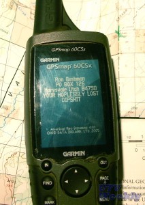
He’d see my latest toy and he’d run out and get one. He never quite got the hang of them, but he tried really hard to figure them out. I guess it was a generational thing. He’s gone now and I recently misplaced my Garmin 60Csx. So, when I was home last I borrowed Dad’s identical unit from Mom who has no idea how to even turn it on. When I turned it on, I laughed out loud…my Dad was funny to the end. Check out this close up of his customized 60Csx power on screen.
I never got around to explaining some GPS stuff to Dad but its clear he isn’t the only one needing some details.
Last week on one of our favorite forums a person requested information about where they could camp near Moab, Utah. Requisites are multiple toy haulers, some triple towing. I responded and gave this person not only pinpoint accurate directions, turn by turn, but also included the precise GPS coordinates. I shared one of my favorite spots. It has great trail access and you can take a huge trailer there, multiple if you like.
The response I got was “Thanks, but can you provide this in Lat Long coordinates?” I respond “No, but you have them simply put the GPS in UTM and enter the coordinates I gave you.” The response was, “These coordinates don’t match your directions.” “OH YES THEY DO!” I mutter to myself. After I straighten this poor fellow out and he discovers I am right, I find myself thinking, “Why does that happen every time?”
So here’s the thing. Its the truth most GPS owners can’t handle. You need two things in order to find something.
1: The right DATUM
2: The right Coordinates
The right DATUM:
I’ll start with the DATUM. Forget that there are lots of them and what the mean or why they exist. The fact is that you need the one that goes with your coordinate. When you go to put the DATUM into you GPS the FIRST thing you do is make sure the DATUM you have and the DATUM setting in your GPS match. Its not a difficult thing to do at all and you won’t harm any furry animals doing it. So just do it.
If someone EVER tries to give you a coordinate make sure they give you the DATUM. If they recorded it on their GPS you need to know what DATUM was set on that GPS when it was given to you. Now its possible they don’t know exactly. Most GPS’s in the US operate using the NAD84/WGS84 DATUM. They are so closely related we just mash them together. If the person can’t tell you make sure you ask them to look at their DATUM setting on their GPS. If they can’t do it, don’t trust their coordinates. Trust me without the correct DATUM you are on a wild goose chase right away.
Take a look at Figure 1. It has the CORRECT coordinate set with the correct DATUM for my favorite camping spot in Moab. Now look at Figure 2. This is what the gentleman on the forum got when he entered the coordinates using the wrong DATUM. BTW, I gave him the DATUM with the coordinate. As you can see he would have been lost trying to get there using Figure 2.
GPS’s are designed to go with maps. Not to be exclusive of maps, or replace maps, despite many having built in maps. You still need to understand a bit about maps to be good with your GPS. That is because GPS is all about mapping, its influence are all from mapping.
So get out your trusty Paiute ATV Trail Map, and the first thing you notice is that the photo on the front was taken by none other than me! Its true, I’m famous in my own mind. But I digress. Open it up and look for a little box like the one in Figure 1. Look closely and you will see it says “When used with Map Datum NAD27…..”. Aha, we have bagged our first clue. So the first thing you should do when you open a map is search its legends and borders and little insert boxes for the DATUM information that was used to produce that map. For whatever reason, the USFS and the BLM tend to publish information in NAD27 so lots of maps are NAD27. But most GPS’ are shipped with NAD83/WGS84 as the default. Sounds like a train wreck right? Right!
Just remember Sparky, no matter what they tell you, you can never have to much DATUM. Get it? Got it? Good.
The right Coordinates:
Okay so the next thing we need is the right Coordinate. This shouldn’t be so hard but it is. “Why?” you ask. I’m glad you ask! First off I think the terms “Latitude” and “Longitude” should be banned, stricken from our language. “Why?” you ask again. Because they are confusing and grossly inaccurate and they smell funny. Take a look at these Coordinates in typical Lat Long formats.
Degrees Minutes Seconds 38°41’07” N 109°54’55” W
Degrees and Decimal Minutes 38°41.118′ N 109°54.917′ W
Decimal Degrees 38.68530° N 109.91528° W
The problem here is we can have three representations of the same thing depending on how we want to use decimals. And maybe more importantly, is the way people hack these up when trying to send you coordinates. I suspect that 99 of 100 computer users cannot figure out how to make that little degree ‘°’ character show up. Its just not on your keyboard. So typing something like 38°41’07” can end up looking like 30 41′ 07″, or even 30 41 07, or 31.41.07 and I can’t begin to tell you how many times the “N” is left off. If I get a coordinate like 38 41118 how do I know whether the person was sending me a Degrees and Decimal Minutes (and omitted a space) or a Decimal Degrees coordinate? Some people omit the third digit in the Decimal Minutes or the last digit in the Decimal degrees. They NEVER tell you that the format is Degrees and Decimal Minutes, they just assume you will know this looking at the coordinate.
So now you can see why Latitude and Longitude smell funny. They are rotten. What we need is something simple that can keep people from screwing up little symbols, space and decimal dots. The best way is to get rid of those things. Yeah thats it, banishment!
Guess what that is exactly what happened. When I work with field people at the USFS or BLM everything they do is in UTM coordinates. DATUMs still matter with UTM, but UTM is SOOOOOO much simpler it is scary. Its much more accurate and it’s really hard to mess up, misinterpret or even transpose. You can still hose yourself with a little work though. I’ll sketch out the basics and you will see why UTM rules.
So here is the SAME coordinate as the above LAT LONG coordinate, its just written in UTM (Universe Transverse Mercator)
UTM: 12S 594343mE 4282413mN
About now a bunch of you are saying “But we understand Lat Long lets stick with it.” Yeah verily I say unto thee “Did you read what I just wrote? Up there, above. The part where I showed you why LAT LONG sucks.” Stick with me here your life is about to get so much easier.
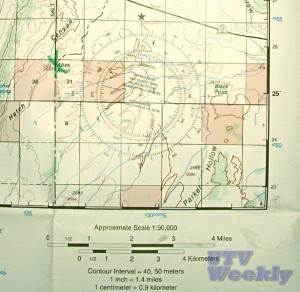
Have you ever tried to look at a map and create a LAT LONG coordinate? Take a look at Figure 2 and notice it has those numbers and tick marks down the edge of the map. See the one for 25′ ? That is the 25 minute line. Not degree, not second but minute. And you can see them going down numerically, the 24′ line is right below that. The problem is this. Exactly how far is a minute? Have you ever seen a ruler marked with seconds? Look all over your map, do you see any scales translating minutes and seconds to feet or meters or miles? Nope. But there is a scale showing miles and Kilometers. This is there because a mile on one map is a different distance on another map because each map is scaled differently. Yeah I know it’s basic but it’s important. The point is we don’t know how far a minute or a second is on this map really. We could invent that stuff but we don’t need to because we can work in Meters and its all right in front of us, on the map. Right next to the 24′ are some more numbers 4250, the 42 is smaller than the 50. These are UTM numbers and those are in meters.
Look at Figure 2 again and lets say you want to tell your friend to meet you at Abes Knoll. Can you see it there at the end of the heavy dashed line, sort of center left? Of course you do I put a green “X” on it. I’ll walk you through creating a UTM coordinate for that location in just a minute.
The UTM coordinate world is first cut into “Zones”. The Paiute ATV Trail happens to be in Zone 12S. If you look at Figure 1 again you will see it says exactly that, well is says 12 but it is 12S. If you are dying to see what Zone you are in go here. http://www.dmap.co.uk/utmworld.htm. Basically Southern Utah and Arizona are in 12S. So Cal is in 11S. This is just a way of cutting the world map into smaller more manageable chunks so we can zero in on our target more quickly. This is basically the same thing we do with Degrees in LAT LONG. In fact, Zone 12S is bounded by LAT LONG lines. Its just a designation for the whole square on the map that covers Southern Utah and Arizona. Then we take that square and carve it up in to meters. Its no accident that the rest of the world likes meters, its how they measured the earth way back in the day to create the latitude longitude lines and thats why it makes sense to use meters today when working on maps.
Now here is the important thing about UTM, always work from left to right (aka west to east) and then bottom to top (south to north). Look at the UTM coordinate for my camping spot in Moab, 12S 594343mE 4282413mN. It tells us to find Zone 12S, then starting in the bottom left hand corner go East 594,343 meters and then go North 4,282,413. These are called the Easting and Northing as in going East and then going North. Its easy peazy. Get it? We start left and work right and then up, Easting and then Northing.
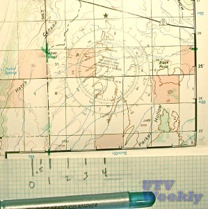
Okay so now we are going to generate out UTM coordinate for Abes Knoll. We know we are in 12S so that goes first. If we just draw straight lines from the green “X” to the closest map edges, using the black grid to make sure we are straight. Now the line that goes down intersects the Easting numbers (ones that increase as we move East) and the one that goes to the right intersect the Northing numbers (ones that increase as we move North). We can see right away that we are between 425000 and 430000 East and 4255000 and 4250000 North. We know that is 5000 meters from each of these Blue tick marks to the other. We can use our scale to figure out about how far we are from each tick mark in meters. Figure 3 and Figure 4 shows us that we are right at 1Km East of the 425000 Easting tick mark (426000E) and 2Km south of the 4255000 Northing tick mark (4257000 N).
There we have it. We tell our friend to meet us at NAD27 12S 426000E 4257000N. W could have easily made 10 evenly space marks on our scale and gotten our measurements to with in 100 meters. That would put out friend within a 330 foot box, I think we’d see him at that point.
This can all be done in the field without any GPS at all. It works the other way around too. If our friend had given us the coordinates of Abes Knoll we could plot it on this map by hand and see that the best approach was from the North.
Keep in mind that any Coordinate aka Waypoint I enter in my GPS will be converted when I change the DATUM or start using UTM. Just make sure the DATUM and the Coordinate were a match set and the GPS will take care of the rest.
So now you know the truth, Lat Long sucks. Learn to use UTM and you will love it. Yeah you can handle that.
I have to go now. I just received another email asking the same question about a camping spot in Moab. Here we go again.
By Shannon Bushman. Shannon is the author of the “Paiute ATV Trial Guide”. It has a LOT of GPS information it. He can found anywhere from Colorado to California driving recklessly and shooting video or broadcasting LIVE from the trail for XXXoffroad. Check out XXXoffroadTV on the front page of XXXoffroad.com.


