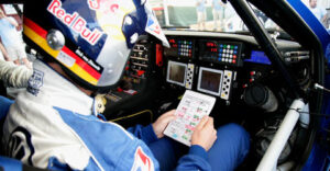
Volkswagen navigators guide the Race Touaregs to success in 2010 Dakar
A crucial task: Without Lucas Cruz, Timo Gottschalk, Clécio Maestrelli, Ralph Pitchford and Dirk von Zitzewitz the Volkswagen “Dakar” successes would have been unthinkable. The five co-drivers in the Race Touareg cockpits must, like their team mates in the race trucks, navigate their drivers perfectly for exactly 9,030 kilometres during the 2010 Dakar Rally otherwise they would be lost. The route is secret throughout, must not be practised and the use of navigational aids is limited.
“Cross country rallying is a multidimensional sport: In contrast to other motorsport disciplines it is by no means only about speed and reliability. The correct orientation in open country is a part of the competition,” explains Volkswagen Motorsport Director Kris Nissen. “Whoever believes that this isn’t a problem in the age of modern satellite navigation is mislead: During the “Dakar” the most effective functions of the GPS device are deactivated in order to challenge the co-driver to the full.”
Fundamentally the co-driver has very few aids: The so-called “Roadbook”, which is only distributed in printed form the evening before each stage, contains distances in kilometres, symbols for orientation, compass information and supplementary tips such as dangers and prominent landmarks in the terrain. “In the notes I highlight specific important information such as direction changes and danger points with different colours,” describes Dirk von Zitzewitz “Dakar” winner in 2009 and co-driver for Giniel de Villiers of his daily evening work. The navigators must stick exactly to the stipulated route.
The tripmaster, a special odometer, helps to compare the completed distance with the values in the roadbook. “However, a great deal of experience is required since the target and actual values can differ from one another due to wheel spin in the desert sand,” knows Ralph Pitchford co-driver for Mark Miller. The GPS device only shows the compass direction and the speed between the way points. It acts primarily as control device for the race stewards and not for the competitor’s orientation, since they can check whether all the planned points along the route were approached correctly. All teams must approach way points that are initially hidden (Way Point Masked). Only when a participant has closed to within three kilometres of the geographical point does the GPS device indicate the correct direction. The point must be passed and the indicator extinguished. Other way points with special functions (Way Point Eclipse, Way Point Visible) make the task for co-drivers even more complex.
In this way every stage becomes a new and often unpredictable challenge – and this not only for the drivers but also for their co-drivers.
Category: Offroad, Press Releases


